MetSul reinforces the alert on an episode of excessive and extreme rains with a high potential for annoyance and impacts on the population with significantly high accumulations of precipitation. There will be several days in a row of atmospheric instability with periods of very heavy to torrential rains, which will generate very large volumes in some localities in southern Brazil, especially between the east and northeast of Santa Catarina and the east of the state of Paraná. .
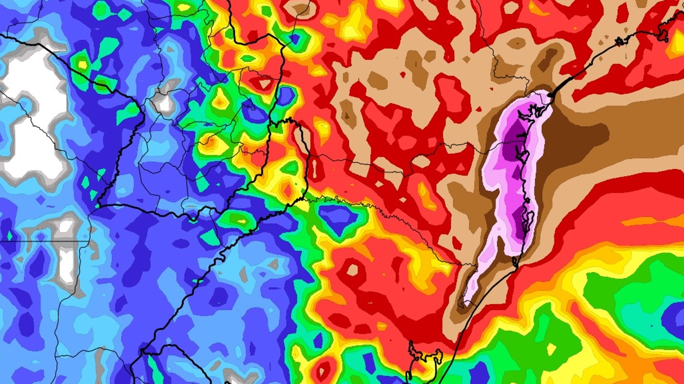
The map above shows the rain projection for the next seven days from the Icon weather model, from the German Weather Service (Deutscher Wetterdienst). There is a trend from significantly high accumulations to extremes in the eastern sectors of Santa Catarina and Paraná.
According to the projection of the Icon model, which is corroborated by other forecasting models used by MetSul Meteorologia, the volumes in the northeast of Santa Catarina, in the east of Paraná and in an area further south of the state from São Paulo, in the Ribeira valley, they can reach levels as extreme as 200 mm to 300 mm with higher isolated accumulations.
The European meteorological model, for example, in its departure from 0Z this Saturday, projects 340 mm in the next ten days for the city of Joinville. For days, the same simulation reports about 300 mm. In other words, despite small daily upward or downward variations in the volume indicator, the trend towards extremely high accruals continued.
The rain is gaining a lot of strength in these areas where models predict accumulated highs this weekend and instability persists through next week. Rain would have the highest volumes in two instants. The first, this weekend, and the second from Tuesday to Thursday, that is to say, it will be a long sequence of days of instability and rain.
The scenario can be considered very concerning and of great danger due to the huge agreement of the models around extremely high and even exceptional rainfall volumes locally. Some simulations project even larger volumes than the Icon and European models for northeastern Santa Catarina, eastern Paraná, and extreme southern São Paulo.
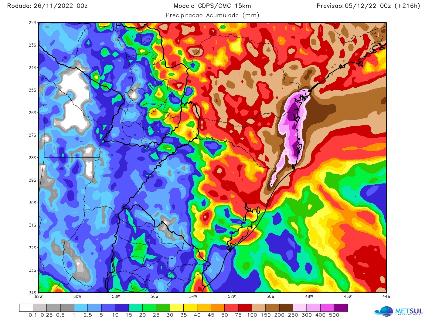
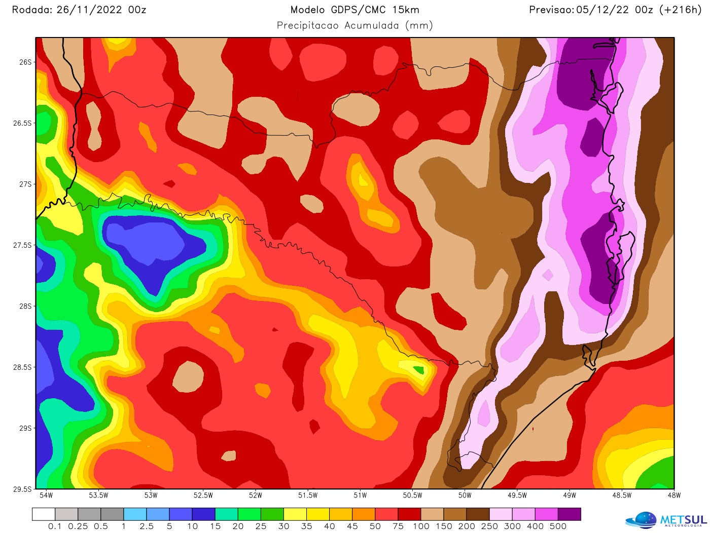
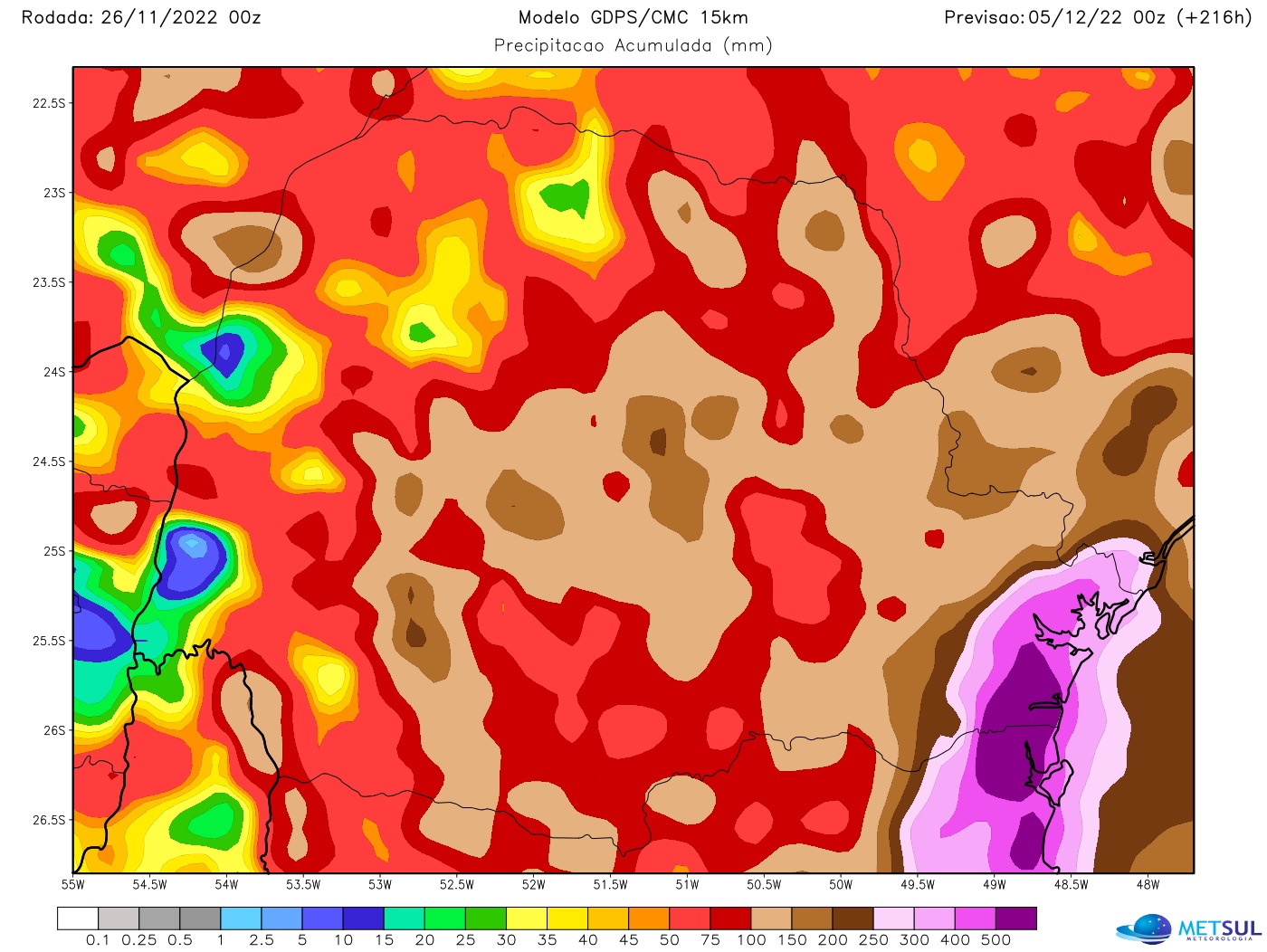
The most aggressive of the models in their rain projections for this episode is that of the Canadian Meteorological Service. This model indicates rain from month to day in these areas. As can be seen on the map, the Canadian model projects cumulative values of 400 mm to 500 mm, and individually up to 600 mm or more, for eastern Santa Catarina and Paraná within ten days up to to December 5.
Rain in Santa Catarina
The extreme rain event of the next few days will not be generalized in Santa Catarina and should only affect part of the territory of Santa Catarina. The tendency is for the most voluminous rains to be concentrated east of Santa Catarina, but, in particular, in a more northeastern area of the state, from the Florianópolis region to the north.
As a result, areas of Greater Florianópolis to the North are expected to concentrate the greatest rainfall volumes over the next seven to ten days. Accumulations can be particularly extreme in the regions of Jaraguá do Sul, Joinville, Balneário Barra do Sul, São Francisco do Sul, Rio Negrinho, Itapoá and Garuva. The more recent model departures have increased volumes for South Santa Catarina, which, although lower than for the North Coast, can be very high and also locally excessive.
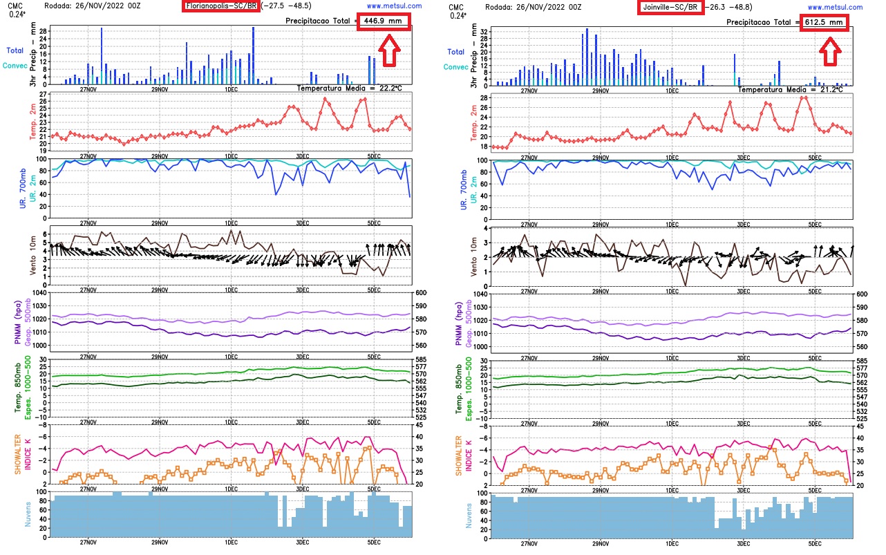
In the Greater Florianópolis area, the rain is expected to be excessively heavy over the next ten days. The models, in general, in their latest rounds have increased the expected volumes for the capital of Santa Catarina and nearby towns, greatly increasing the risk of disruptions and impacts due to rain in the region.
rain in Parana
Like Santa Catarina, rainfall in Paraná can be excessive to extreme only in the more eastern areas of the state. This includes municipalities such as Matinhos, Paraná and Guaratuba, Morretes, Guaratuba and Antonina. Rain is expected to be extreme from the Serra do Mar area towards the coast.
The rain is expected to intensify a lot in this area of Paraná this weekend and persist for most of next week with very high cumulative values again towards the middle of next week. At various times, the rain is expected to be heavy to torrential, generating significant volumes over short periods.
The city of Curitiba and its metropolitan area, due to its geographical position further east and next to the Serra do Mar, will also experience very high rainfall volumes and with a risk of disruptions. The highest accumulation begins to occur this weekend and rain is expected every day, at times moderate to heavy, every day at least until December 5th.
Which increases the risk of extreme rain
The accumulations in several towns on the coast and in Serra do Mar will be expressive, totaling months in a few days and one of the reasons will be the orography of the region, that is, the relief and its interaction with the Moisture flows into the atmosphere from the eastern quadrant. This is called orographic rain.
Humidity that comes from the ocean, brought by the wind from the southern quadrant to the eastern quadrant, and that the inhabitants of Santa Catarina call “Lestada”, due to a mass of cold air at low pressure on the coast, when it meets the barrier of the Serra relief, it rises in the atmosphere and finds a lower temperature. This leads to condensation and the occurrence of relief-induced or orographic rainfall.
Orographic rainfall events are high risk because they tend to locally bring very high precipitation accumulations that often end up exceeding numerical model projections. The coasts of Santa Catarina, São Paulo and Rio de Janeiro are the most exposed to extreme rainfall events of an orographic nature in Brazil, with a long history of catastrophic situations due to this type of precipitation.
Risk of disturbances and flooding
It is inevitable, given the rain scenario projected by the numerical models, that there will be inconvenience and danger for the population. One of them includes flooding of rivers and, therefore, flooding. With accumulations of 300 mm to 500 mm in a few days, and even more in isolation, there is a risk of major flooding in certain areas.
The northeastern region of Santa Catarina, in particular the Itajaí-Açu River Valley, is the one that will require the most attention in terms of hydrological conditions. Cities like Rio do Sul and Blumenau will have to watch local Civil Defense advisories very carefully.
The risk of streams and creeks overflowing is also critical due to the large volumes added over several days and torrential rain events, after all at various times the rain must be intense with heavy accumulations of rain over a short period of time. .
The succession of days of heavy rains and the extreme accumulations projected by the models will create the risk of critical landslides to the east and northeast of Santa Catarina, as well as to the east of Paraná and to the extreme south of Sao Paulo.
The east and northeast of Santa Catarina, in particular, will have a greater risk of landslides on the slopes due to the terrain of the region. Falls of barriers are expected and there is a high probability that traffic will be affected on certain roads with partial or total blockages, either by accumulations of water or landslides.
How to consult the maps
All rainfall maps in this bulletin can be viewed by our subscriber (subscribe here) in our part of the map🇧🇷 The platform also offers rain, frost, temperature, hail hazard, wind, humidity, air pressure, snow, soil moisture and fire hazard maps and lightning, among other variables, with updates two to four times a day, depending with each simulation. In the maps section, it is also possible to consult our very high resolution WRF model of MetSul.

“Total troublemaker. Alcohol aficionado. Social media specialist. Friendly travel nerd.”